Ambiance: atmosphere, feel, setting, environment, mood, character, air, quality
Heartland: core, hub, nucleus, focus, centre, middle
Here: now, at this
time/point/juncture
Locale: location,
setting, place, milieu, area,
locality, site, spot
Locality: area,
neighbourhood, zone, vicinity, section, quarter, ghetto, district
Milieu: setting,
environment, scene, background, situation, location, locale, ambiance
Neighbourhood: area,
region, district, locality, zone, quarter, vicinity
Surroundings:
environs, settings, environments, backgrounds, backdrops,
atmospheres, ambiences
Vicinity:
neighbourhood, district, locality, area, purlieu,
locale

The rain is already close as Leo and I lock up and disappear
into the weekend. The forecast predicts rain is still two hours off, but the
dark phalanx of cloud marching eastwards suggests otherwise. The first spots
are felt before we’ve walked a quarter of a mile and my wet weather gear is out
and on as the curtain of rain washes over us. The ferry disappeared into it
moments before and is gone, like disappearing into a waterfall. The wind is
fidgety: a low breeze carrying the whiff of Newhaven’s industrial Saturday
morning rises to a headwind, surfing the first enthusiastic rain wave, then
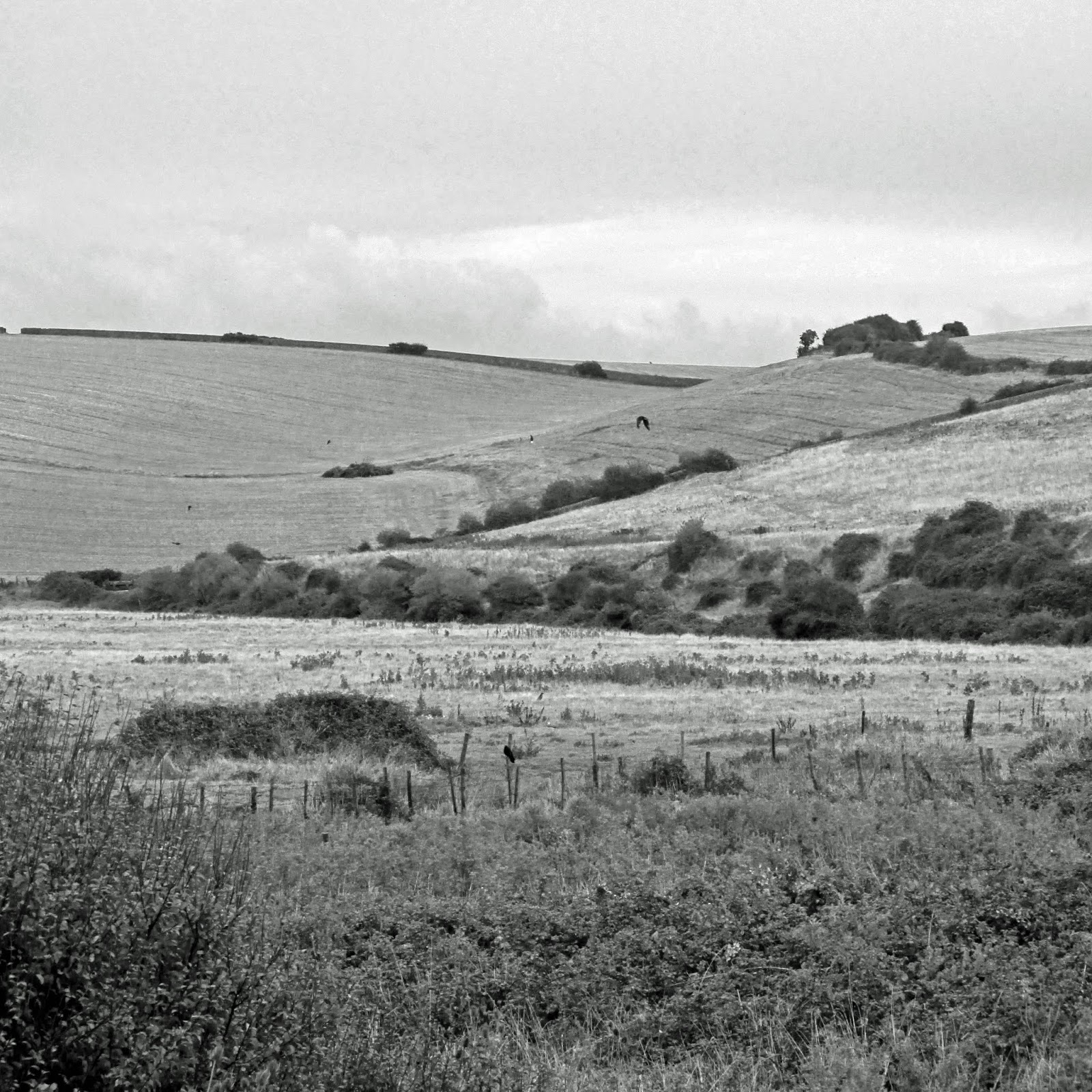
settles back to near calm with the steady rain. We are crossing the chalk east
ridge of the Ouse valley in search of the floodplain below. I have felt a
growing appetite to watch and hear Curlew as they return from their upland
nesting sites to coastal wintering grounds. We will explore the heartland of
the Ouse floodplain. The tide is high and rising, so there is a good chance
they will be sitting it out somewhere in or around the Ouse Estuary Local
Nature Reserve. From a trig above The Rookery, the narrow ribbon of the Mill
Drove shines wet and bisects the Tide Mills ruins. To its east the land
stretches flat to the Buckle and curves inland through the old Pelham estate
towards Bishopstone and its church sat slightly elevated above the once-marsh,
where now a criss-cross of drains cut through damp meadows which still become a
shallow wetland in winter. Curlews and countless other waders once would have
piped the mudflats at low tide. Surrounding escarpment and steep ridges show
where the tides would once have lapped up to twice-daily. This, then, shall be our
starting point.

 The road to the village at Bishopstone rises gently, so once
over the stile built into the flint wall, one drops down into the floodplain
below. A path into Bishopstone Wood - the Rookery - is a causeway
between two ponds which dry out during good summers. Three other ponds lie nearby. They're alive with
dragonflies then, but none are seen today as I pass towards the woodland edge.
Great trees planted by Thomas Pelham-Holles, the Duke of Newcastle and twice
Prime Minister, sometime after he inherited the land from his uncle in 1711, mark
the boundary between the wood and pasture. They are outliving a decaying flint
wall that follows the tree line and marks the route of Duke's Walk through
the trees and up towards Norton Top. One of the largest sycamores I know stands
over the corner with great vertical boughs reaching like outstretched fingers towards
the sky. Its bark is thick with lichen-crusted scales. Elms and big beeches
which may be nearly 300 years old mark the edge further up.
The road to the village at Bishopstone rises gently, so once
over the stile built into the flint wall, one drops down into the floodplain
below. A path into Bishopstone Wood - the Rookery - is a causeway
between two ponds which dry out during good summers. Three other ponds lie nearby. They're alive with
dragonflies then, but none are seen today as I pass towards the woodland edge.
Great trees planted by Thomas Pelham-Holles, the Duke of Newcastle and twice
Prime Minister, sometime after he inherited the land from his uncle in 1711, mark
the boundary between the wood and pasture. They are outliving a decaying flint
wall that follows the tree line and marks the route of Duke's Walk through
the trees and up towards Norton Top. One of the largest sycamores I know stands
over the corner with great vertical boughs reaching like outstretched fingers towards
the sky. Its bark is thick with lichen-crusted scales. Elms and big beeches
which may be nearly 300 years old mark the edge further up. It takes a little imagination to see a harbour here with
ships moored up, sailing between Rookery Hill and Hawth Hill to and from the
river proper and the sea beyond, but this was once the scene. Perhaps the ponds
are its last trace? To imagine this better, it is helpful to view the
floodplain from Rookery Hill above. The hill was once a promontory bounded on
three sides by the estuary. It has Bronze Age barrows and Romano-British and
Saxon settlements which once looked across the tidal flats to neighbouring
settlements on Hawth Hill and beyond across the floodplain to the sea. Much of
this is buried beneath the bungalows of the Harbour View estate. The river
followed an eastward course to the foot of Seaford Head until about
1567, and a ferry-boat operated at Bishopstone to transport people and
livestock to and from the shingle spit and its road which stretched along the coast, beyond the parish of Sutton. In 1567
the river burst through the spit somewhere between what is now The Buckle and Tidemills.
The channel beyond silted up and marked the end of Seaford as a Cinque Port. Only
The Old Brickfield, The Salts and Martello Fields, the position of St. Leonard’s
Church in the old parish of Sutton and the course of Steyne Road – steyne meaning a stony place – are
physical hints of the old course of the river. Imagine the joy of being able to
bypass the old port and its rules and taxes. Was there human agency involved
with the change in the river’s course?
It takes a little imagination to see a harbour here with
ships moored up, sailing between Rookery Hill and Hawth Hill to and from the
river proper and the sea beyond, but this was once the scene. Perhaps the ponds
are its last trace? To imagine this better, it is helpful to view the
floodplain from Rookery Hill above. The hill was once a promontory bounded on
three sides by the estuary. It has Bronze Age barrows and Romano-British and
Saxon settlements which once looked across the tidal flats to neighbouring
settlements on Hawth Hill and beyond across the floodplain to the sea. Much of
this is buried beneath the bungalows of the Harbour View estate. The river
followed an eastward course to the foot of Seaford Head until about
1567, and a ferry-boat operated at Bishopstone to transport people and
livestock to and from the shingle spit and its road which stretched along the coast, beyond the parish of Sutton. In 1567
the river burst through the spit somewhere between what is now The Buckle and Tidemills.
The channel beyond silted up and marked the end of Seaford as a Cinque Port. Only
The Old Brickfield, The Salts and Martello Fields, the position of St. Leonard’s
Church in the old parish of Sutton and the course of Steyne Road – steyne meaning a stony place – are
physical hints of the old course of the river. Imagine the joy of being able to
bypass the old port and its rules and taxes. Was there human agency involved
with the change in the river’s course?Back below Rookery Wood, the lush grass and damp ground is no good for sheep grazing and a small herd of well-behaved cattle spends most of the year here and through the open gate leading into the field to the north, by the few houses. This land has lived different lives throughout history and the peaceful inertia of today may once have been rather more influenced by the tides and industry of the local people. This is a common theme that will recur as I walk south and then westwards through the floodplain. Standing now though in the once-estuary, where trees and pasture have replaced the wooden ships and their harbour, ripples of history can still be felt. The lowest levels are still inundated after the winter rains each year and the land is usually off limits during the early months. At these times it might even be navigable by boat.